
The geological setting of the Jurassic ironstone mines and quarries in the Corby- Wellingborough district
Introduction
Mining and quarrying of ironstone in the East Midlands ceased in 1980 with the closure of the ‘deep’ quarries surrounding Corby; the last mine, at Irthlingborough, having closed in 1966. Safety concerns at the abandoned mines and the utility of the quarries for landfill has meant that opportunities to inspect the ironstone beds in-situ after 40-odd years are now surprisingly rare. Even where visible in remnant quarry gullets the ironstone is badly weathered, commonly with severe oxidation and development of ‘box-structure’ concretions obscuring bedding structure and leaching fossil fauna. Unless some access to ‘fresh’ sections in mines can be assured our knowledge of the ironstone geology will rest increasingly on the archival record.
Sedimentary rocks with above 15% iron content are termed ‘ironstone’ by geologists. By the mid-1860s it became known that in Northamptonshire there were extensive areas of Jurassic rocks within which the iron content of beds 12-20 ft thick reaches 30-35 % and where such deposits lay at shallow depth exploitable in quarries. For over 100 years the ironstone then became a national strategic asset (in two World Wars) and its extent, thickness, depth below surface, internal mineralogical variation and content of elements undesirable for steel making aroused extremely detailed study, both commercially and by the national geological survey.
The Jurassic System in Central England
Jurassic rocks extend at preserved outcrop from Dorset to N Yorkshire and from there into the North Sea Basin where they form major targets for hydrocarbon exploration. Onshore they dip at very gentle angles to the SE and have been divided into three major divisions (Series), namely Lower, Middle and Upper. The Lower is historically the “Lias’ clays (noted for its fossil fauna of ammonites and marine reptiles) with two locally important ironstones. the Middle begins with the Northampton Sand Ironstone and is succeeded by fine sandstones clays and marls and both shelly and oolitic limestones (noted for the superb building stones of Leckhampton, Taynton, Barnack and Clipsham). The Upper is dominated by clays (noted for brick-making and again with fossils of ammonites and marine reptiles). The higher levels of the Upper Jurassic (with the organic rich clays which form the principal hydrocarbon source rocks in the North Sea) are largely removed by erosion in the East Midlands.
The sediments comprising these strata are thought to have been deposited in a seaway separating landmasses to W and SE (Fig 1). The width and depth of the seaway increased over time as regional sea levels rose (Fig 2) but the Middle Jurassic rocks record a period of interruption to this trend with several minor episodes of narrowing / shallowing related to uplift of the land masses.
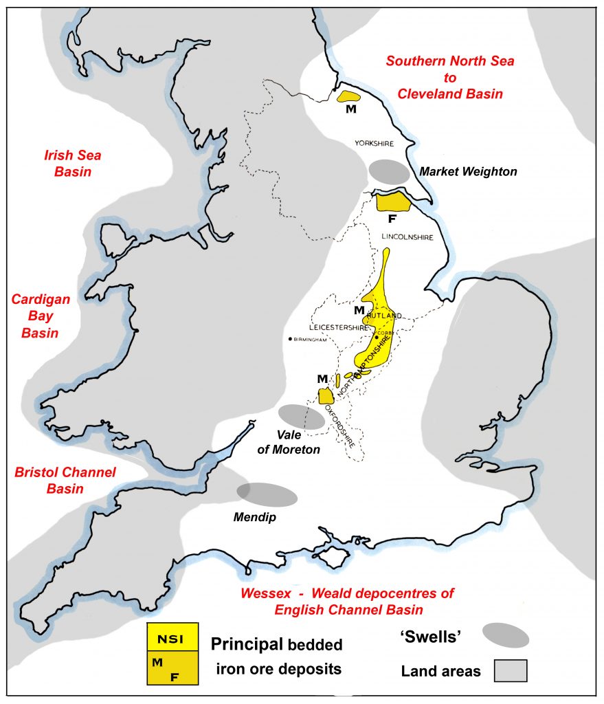
Figure 1. Generalised map of the distribtion of Jurassic ironstones in Central England in relation to their contemporary geography.
The ironstones were deposited on the SE margin of a shallow seaway separating deeper water (‘basinal’ areas to north and south. Time equivalent strata on the inferred NW margin of the seaway have been removed by regional tilting and erosion. Within the seaway local areas of uplift (‘swells’) reduced, and locally prohibited / removed, deposition but in other areas simply induced shallowing of the sea with deposition of ironstones.
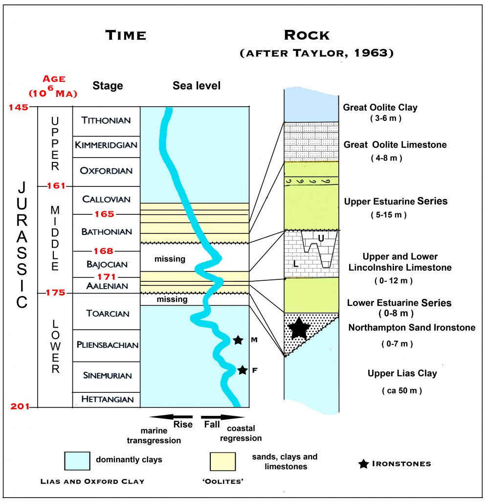
Figure 2. The stratigraphic record of time and rock succesion in the Corby – Wellingborough area in the context of sea level fluctuations.
To facilitate comparison with the stratigraphic nomenclature in Hollingworth and Taylor (1951) and Taylor (1963) the figure uses Upper Estuarine Series and Lower Estuarine Series respectively for the more modern terms Rutland Formation and Grantham Formation; the original term ‘Series’ being now restricted to rocks of an age corresonding to an Epoch of time, eg Middle Jurassic. The full modern stratigraphic usage is given in Herbert et al (2005) in the revised memoir for the 1;50,000 sheet 171 (Kettering). The internationally recognised divisions of time are the Stages (Hettangian to Portlandian). Sea level curve simplified after Cope (2006, fig 14.2).
The principal workings in the Northampton Sand Ironstone (NSI) lie in the Corby-Wellingborough district (Figure 3) of Northamptonshire but locally important quarried workings extend (just) into Leicestershire (Sproxton), Rutland (Cottesmore, Exton Park) and follow the Oolite escarpment into S. Lincolnshire (Colsterworth and Greetwell). At Greetwell very significant production was obtained by mining.
Quarrying of the Liassic Marlstone Ironstone (M) was extensive in Leicestershire (Holwell, Woodsthorpe) and N. Oxfordshire (Adderbury, Hook Norton) and in its local development in N. Yorkshire (Cleveland hills, the ‘Dogger’); also in the slightly older but important Frodingham Ironstone (F).
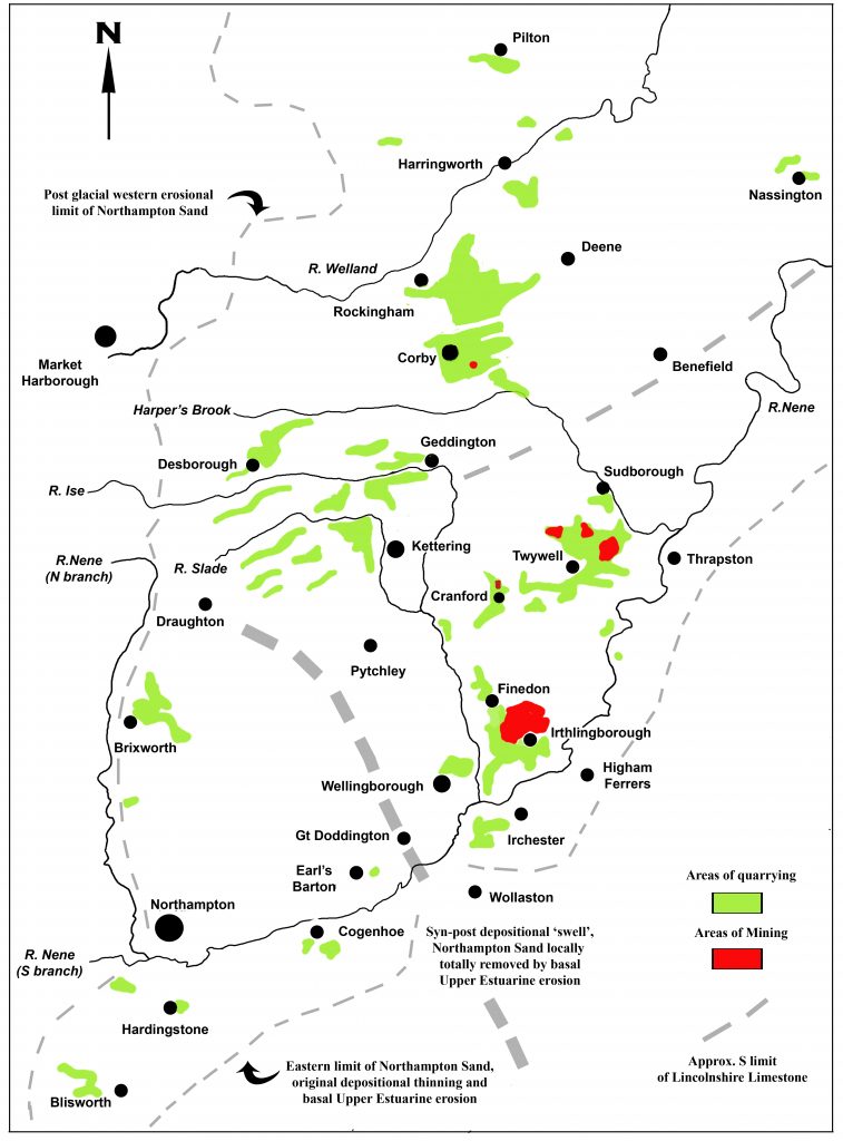
Figure 3. Simplified map of the main areas of ironstone extraction in southern Northamptonshire, based on Hollingworth and Taylor (1951), plate II.
Deposition of the Middle Jurassic Series between Oxfordshire and Lincolnshire
Study of the fossil faunas has shown that the succession of rock strata does not represent continuous deposition in time (Fig 2). In particular it contains two significant unconformities, at the base of the Northampton Sand Ironstone and the base of the Upper Estuarine Series, both of which record erosional NW-directed coastal advance into the seaway possibly combined with uplift of strata on the landmasses allowing increased depth of weathering and pace of erosion there.
The Northampton Sand Ironstone immediately above the basal unconformity commonly contains phosphatic nodules reworked from hinterland erosion. The ironstone was deposited in shallow offshore waters as shown by marine fossils; probably on shoals separated by tidally-influenced channels, ideal conditions for the formation of oolites. The iron was presumably sourced from deep weathering of suitable rocks on the landmass (possibly the iron-rich Triassic sediments) and transported to the coast by rivers before being precipitated in carbonate muds or around grains of sand or shell fragments as ooids.
The Lower Estuarine Series is essentially non-marine in Northamptonshire and records regression, locally erosive, of coastal plain / barrier sands and plant-rich swamps (‘coaly beds’) to the NW. The sands are extensively leached and were locally worked as ‘ganister’ at Burton Latimer. Ironstones are absent, either from total erosion of their source or from diversion of the supplying rivers.
The Lincolnshire Limestone by contrast records the return of offshore, but clear water, deposition of carbonate ooids after marine transgression. Local more sandy, fissile, beds at its base are worked for slate at Collyweston. During deposition of the Upper Lincolnshire Limestone it appears that tidal asymmetry between the linking basins to NE and SW induced the cutting of a major offshore tidal channel complex which locally removed the lower portions of the Limestone. The infill includes the well-known formerly worked building stone at Weldon. Long-spired gastropods are common fossils therein, eg at the Bridge quarry (Weekley Hall Woods).
There follows a resumption of ‘estuarine’ conditions above the unconformity at the base of the Upper Estuarine Series, a mix of migrating coastal plain /deltaic environments in which waters were generally brackish. A more marine limey band in the Wellingborough district is rich in fossil oysters (Ostrea).
Over most of the SE extent of the Orefield the highest portion of the overburden (below the glacial drift) is the Great Oolite Limestone. This records a marine transgression with muddy limestone deposition (generally poor quality building stone) containing rich bivalve faunas including the large clam shells that used to be collectable in the Thrapston quarry.
The Orefield in Northamptonshire
By far the most important quarries and mineslie in an areadefined by Corby, Thrapston, Irchester and Desborough (Figure 3). Southwest of the Slade and its tributary interfluves the ironstone is at shallow / outcrop depth in the Glendon-Loddington district. It thins and becomes more siliceous to the SW and is locally absent over the Draughton-Pytchley-Gt.Doddington ‘swell’: probably approaching its depostional limit south of the Nene towards Blisworh.
North and east of the Ise the overburden thickens and by Harper’s Brook includes NW-thickening Lincolnshire Limestone below thick glacial drift, necessitating pre-extraction blasting in the deep Rockingham-Oakley-Deene quarries serving the Corby ironworks. At Barn Close a small mining trial was attempted but not pursued. Northeast of Deene the ironstone is of of similat quality to that around Corby but too deeply buried for quarrying and would have needed deep mining techniques for extraction.
East of the Ise and south of the Geddington-Benefield line the Lincolnshire Limestone is absent due to erosion below the Upper Estuarine Series but the southeasterly stratal dip generally preserves the relatively thin and easily removed Great Oolite Limestone (locally quarried as a flux for blast furnaces using siliceous iron ore in the Cranford-Tywell district)). This limestone is preserved in the cover of the Finedon-Irthlingborough mines and over much of the Slipton – Islip mines.
Stratigraphy of the Northampton Sand Ironstone
The Northampton Sand was deposited as a variable mix of three major components, quartz sand / silt, carbonates and hydrous aluminosilicates (clay) minerals. The mix was not random and its changes over time allow the defintion of five members (‘Groups’) as defined by the Geological Survey (Figure 4). The members are fairly persistent over the extent of the orefield although on small scale their mutual relations are commonly erosive.
The carbonate is both that of calcium (in the limestones) and of ferrous iron (siderite) which forms by substitution of ferrous iron into the calcite (calcium carbonate) lattice; the hydrous aluminosilicates include the non iron-bearing kaolinite (formed from the weathering of feldspar) and ferro-magnesian varieties such as chamosite (and the chemically similar berthierine) which form from diagenetic incorporation of ferric iron as ferrous iron within a phyllosilicate lattice under reducing conditions (Bhattacharyya, 1983). The chamosite occurs both as ooliths and as a muddy matrix to ooliths, quartz sand and shell fragments. The kaolinite may also occur as ooidal pellets.
The best, and fortunately the thickest division, is the Main Oolitic Ironstone, generally 2-3 m thick where worked. The Lower Siderite Mudstone Limestone Group which was generally ‘hard’ was left as a working floor capable of supporting heavy machinery (where this was neglected the extraction of a 650 ton R&R 5360 shovel with its runners sunk into Lias clay was a sight to behold!) Although rich in iron the requirement to remove carbonate (in calcining banks and a very dirty job) before smelting made working the primarily sideritic groups unattractive. Fortunately the unattractive phosphatic nodules are confined to the base of the ‘hard’ floors.
Taylor (1963) notes that the two Chamosite-Kaolinite groups do not contain fossils: this may indicate less marine (‘back- barrier’ ?) conditions of depsition.
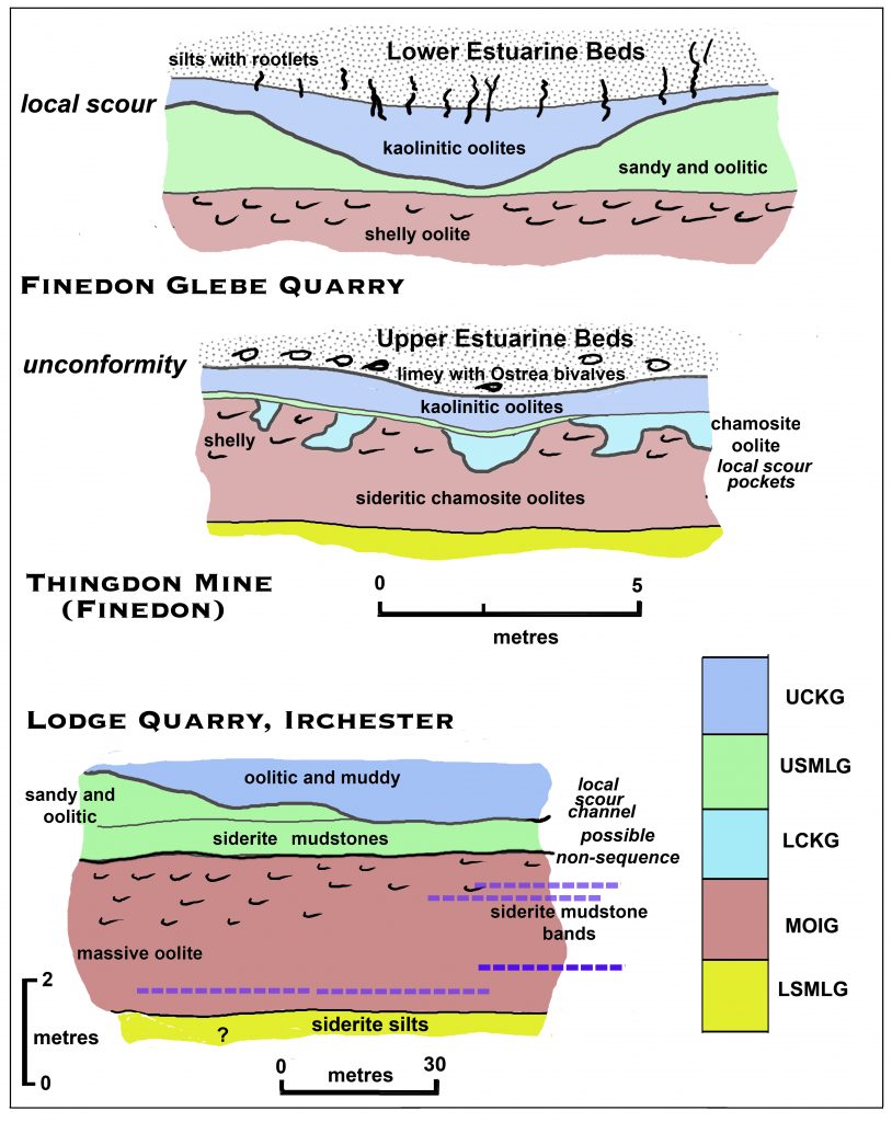
Figure 4. Sections in the Ironstone in the Finedon area showing the variety of erosion surfaces between the internal divisions; simplified after figs 4, 6 and 7 in Hollingworth and Taylor (1951).
The Finedon sections are at natural scale and show the locally steep-sided nature of the erosion surfaces (and possibly solution cavities); the Irchester section has a vertical exaggeration of x15 and illustrates a much more gentle scour surface. Note that the unconformity below the Upper Estuarine Beds in this section follows the sag in the UCKG which may indicate large-scale local solution of the MOI in post-Upper Estuarine time.
Key to Groups
UCKG, Upper Chamosite Kaolinite Group; USMLG, Upper Siderite Mudstone Limestone Group; LCKG, Lower Chamosite Kaolinite Group; MOIG, Main Oolitic Ironstone Group; LSMLG, Lower Siderite Mudstone Limestone Group
Quality of the ore as quarried and mined
The regular provision of a predictable volume and grade of iron / silica / lime ore for the furnaces required extensive pre-extraction sampling by boreholes. Grades varied as reflecting both original depositional facies and degree of subsequent weathering. In general lime (carbonate) content increases to the NW (offshore) and silica (quartz) to the SE (nearshore) where the stone is fresh and ‘green-hearted’. Weathering of the primary ironstones enhanced the silca content, reduced the lime content (leaching shelly fossils to leave moulds) and produced the dark brown iron oxy-hydroxides such as limonite and goethite and also hematite (ferric oxide) crusts which are so obvious at outcrop.
Now that most quarries are infilled inspection of the Groups is very difficult and the best exposures of layering above the Main Oolitic Ironstone in mines are afforded by roof collapse where protected by the Great Oolite Limestone !
Where the ironstone contained iron pyrite (ferrous sulphide) acidic oxic rainwater seepage in mines formed the alteration product melanterite (a hydrous iron sulphate), commonly of attractive green colour. Sideritic ores were commonly recrystallised on exposed surfaces to masses of globular sphaerosiderite.
Acknowledgements
The Memoir by Hollingworth and Taylor is a classic work of which the I have made frequent use. I well recall as a young research student meeting Hollingworth over a beer and hearing his happy memories of mapping in the mutually familiar quarries around my home town of Kettering.
I am grateful to the Boreholes Dept. of Messrs Stewarts and Lloyds for holiday employment at Brigstock as young geologist in 1959-60 when I was examining the Lower Estuarine Series; also to the foremen of many quarries (especially Cowthick) who allowed me access to roam in the days when ‘health and safety’ was policed with common sense.
References
Bhattacharyya, D.P. 1983. Origin of Berthierine in Ironstones. Clays and Clay Minerals, 31, 173-182.
Cope, J.C.W. 2006. Jurassic: the returning seas. In:Brenchley, P.J. & Rawson, P.F. (eds) The Geology of England and Wales (2nd edition), The Geological Society, London, 325-363.
Herbert, C, Barron, A J M, Reeves, H J, and Smith, N J P. 2005. Geology of the Kettering district — a brief explanation of the geological map. Sheet explanation of the British Geological Survey. 1:50 000 sheet 171 Kettering (England and Wales). Keyworth, Nottingham: British Geological Survey.
Hollingworth, S.E. and Taylor, J.H. 1951. The Northampton Sand Ironstone, stratigraphy, structure and reserves. Memoir of the Geological Survey of Great Britain, London, H.M.S.O. pp 211.
Taylor, J.H. 1963. Geology of the country around Kettering, Corby and Oundle. Memoir of the Geological Survey of Great Britain, Sheet 171 (England & Wales). London, H.M.S.O. pp 149.
Anon, Undated, Ironstone and Agriculture. National Council of Associated Iron Ore Producers. pp 28
Article above kindly supplied by an eminent local geologist.
Pictures below are archive images showing subjects of geological interest:
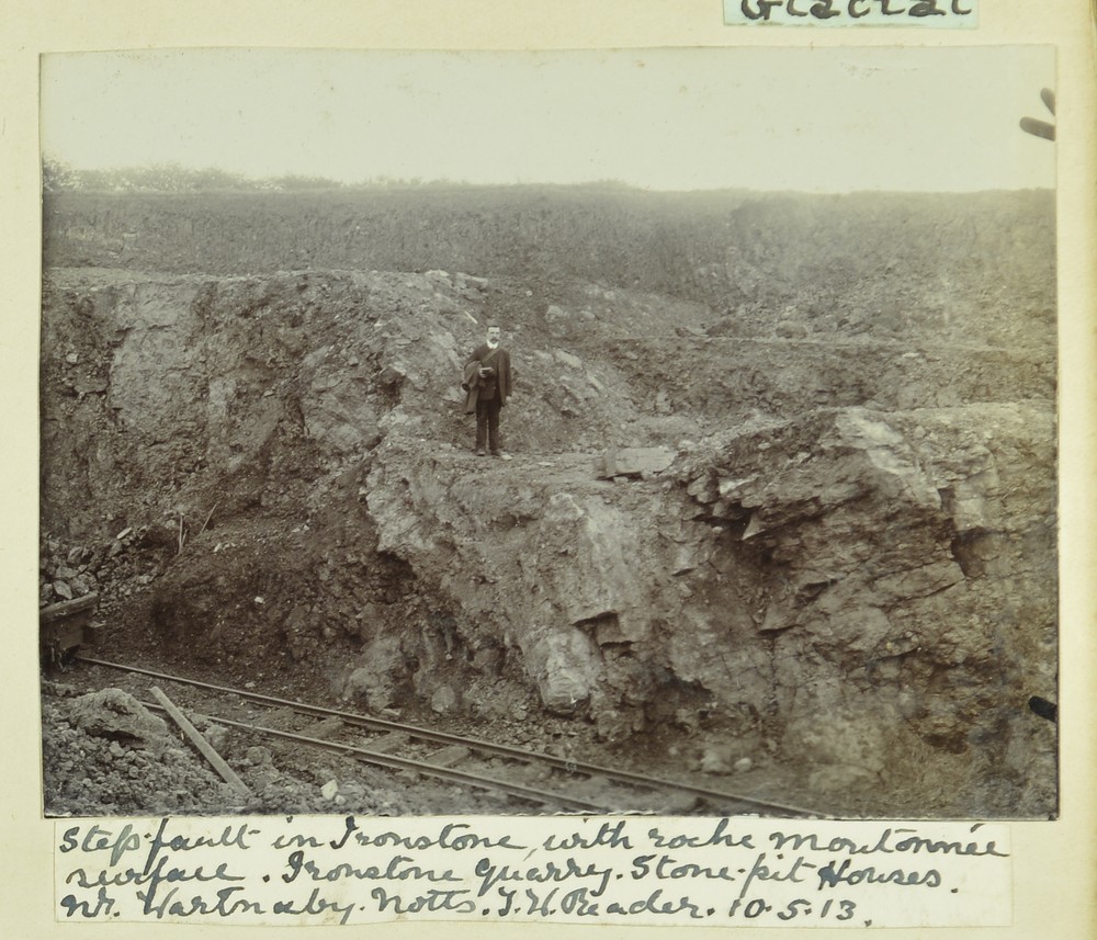
Step fault in Ironstone with Roche Moutonnee surface. Ironstone Quarry. Stone Pit Houses nr Wartnaby, Notts. 10/5/1913. Photo from BGS archive
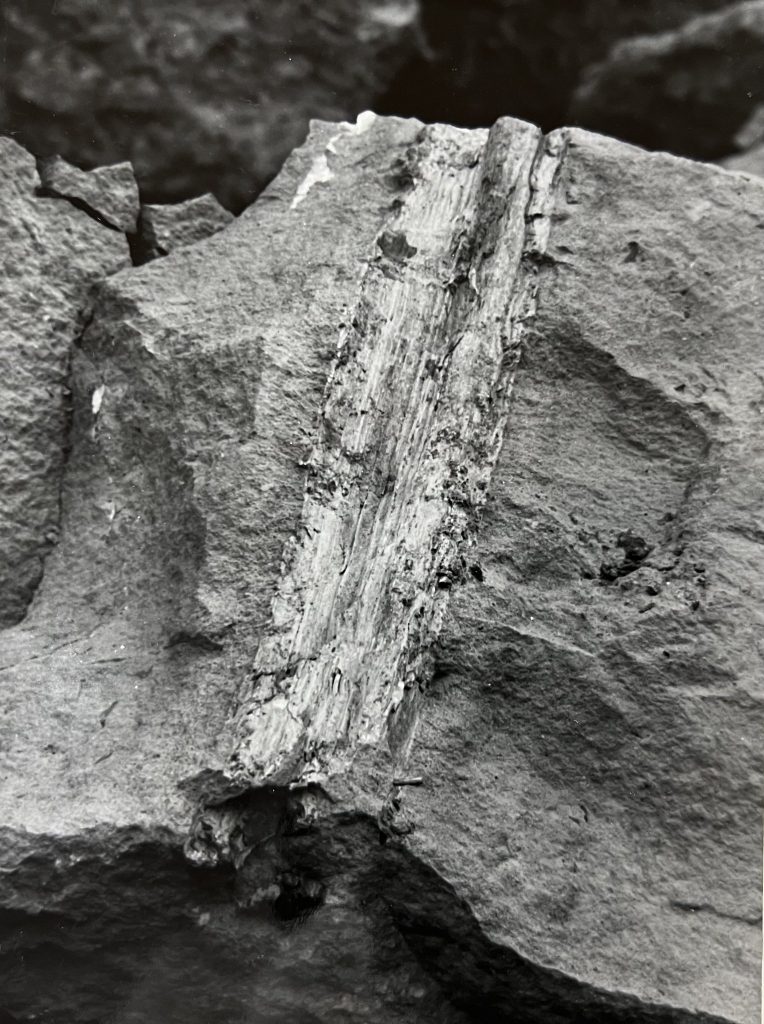
A tree fossil in a piece of ironstone.
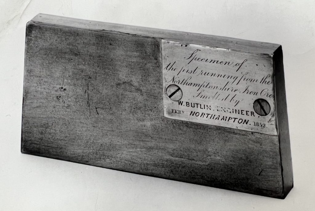
Specimen of the first piece of smelted Northamptonshire ore . 1852
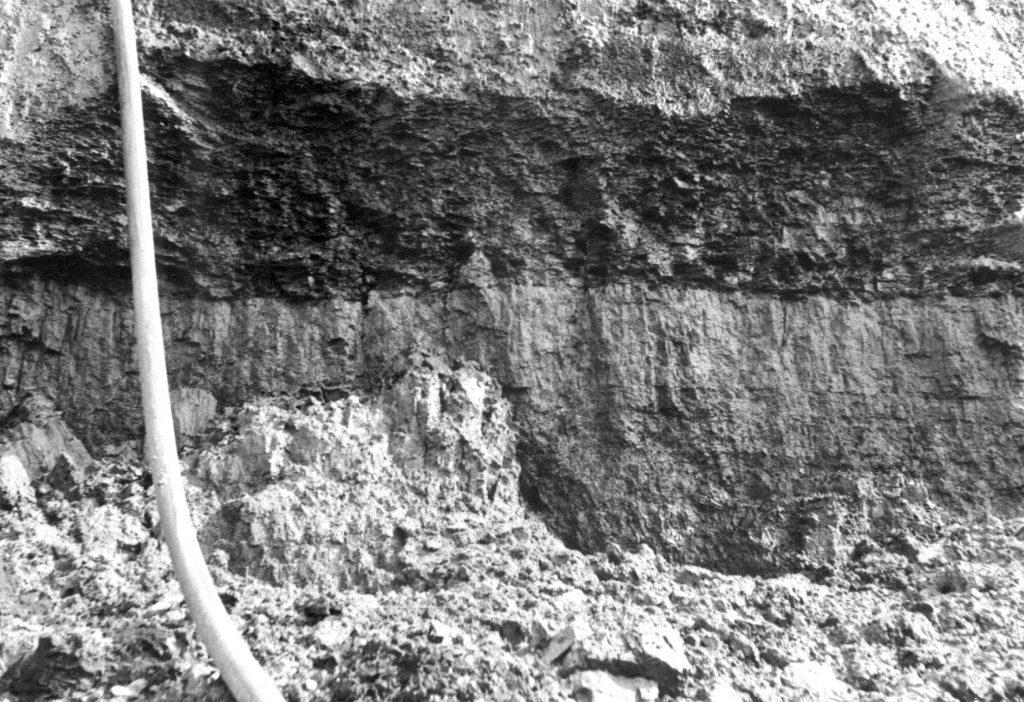
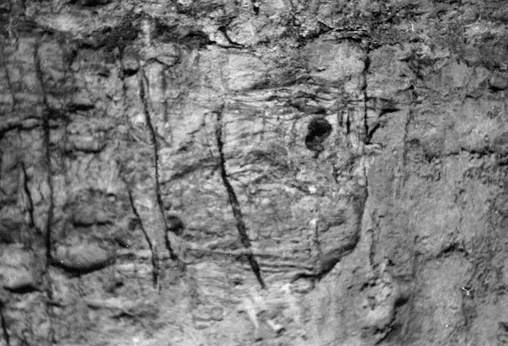
coaly bed’ on laminated silty sandstone in the Lower Estuarine Series
fossil roots, in the Lower Estuarine, sandstone below the ‘coaly bed’